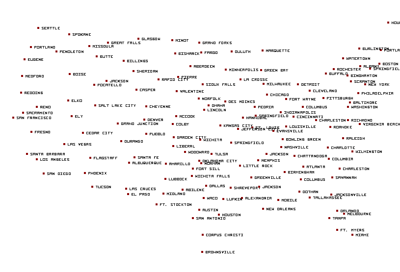
El Paso, TX...Albuquerque, NM...Las Cruces, NM...Santa Fe, NM...South Valley, NM...
Critical
38,804
615,400
Rio Rancho, NM...Roswell, NM...Douglas, AZ...Las Vegas, NM...Los Alamos, NM...
ZCZC SPCFWDDY2 ALL
FNUS22 KWNS 260624
Day 2 Fire Weather Outlook
NWS Storm Prediction Center Norman OK
0124 AM CDT Sat Apr 26 2025
Valid 271200Z - 281200Z
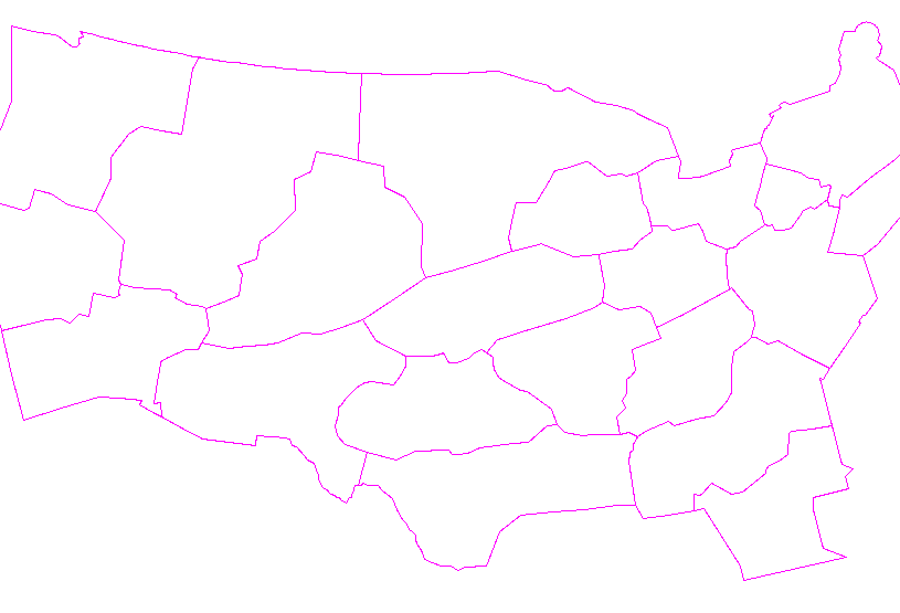
...EXTREMELY CRITICAL FIRE WEATHER AREA FOR CENTRAL AND SOUTHERN NEW
MEXICO INTO FAR WEST TEXAS...
...CRITICAL FIRE WEATHER AREA FOR PORTIONS OF EASTERN AND CENTRAL
NEW MEXICO INTO FAR WEST TEXAS...
...Synopsis...
As a mid-level trough moves over the Great Basin during the day
Sunday, an accompanying southwesterly mid-level jet maximum is
forecast to overspread the southern and central Rocky Mountains.
Strong lee cyclogenesis at the surface east of the central Rockies,
as well as deep boundary layer mixing beneath the jet core across
the Southwest, will result in strong southwesterly surface winds and
dry conditions from the Four Corners region into the southern High
Plains. These conditions will be responsible for a corridor of
concern for Extremely Critical fire-weather across central and
southern New Mexico into far West Texas.
...Central and Southern New Mexico into Far West Texas...
00Z Ensemble guidance from the HREF suggests there is high
confidence in widespread 30+ MPH winds along with the potential for
single-digit relative humidity. Forecast sounding profiles suggest
an ensemble mean mixing depth at or exceeding 3 km AGL / 600 mb, and
ensemble minimum sustained winds exceed Extremely Critical criteria.
With current ERC fuels guidance showing fuels exceeding the annual
90th percentile, conditions will be supportive of rapid wildfire
ignition and spread. While low relative humidity and high winds will
exist from northwest New Mexico into the Four Corners, as well as
southeastern Colorado, fuels further north do not appear to be
overly receptive to wildfire ignition and spread at this time.
..Halbert.. 04/26/2025
...Please see www.spc.noaa.gov/fire for graphic product...
CLICK FOR DAY 2 FIREWX AREAL OUTLINE PRODUCT (KWNSPFWFD2)


 @NWSSPC

