"DOPPLER ON WHEELS" RADAR IMAGES
MAY 27, 2001
(Information provided by Doppler on Wheels research meteorologist Curtis Alexander)
The Doppler on Wheels mobile radar research vehicle and research team members traveled to southwestern Kansas on May 27, 2001 to obtain detailed up-close radar data from supercells (rotating storms) and tornadoes. In the vicinity Garden City, Kansas the mobile radar observed the evolution of the supercells and the development of the dominating storm outflow winds that became the derecho gust front. They also measured how strong the extreme winds were just above the ground. The Doppler on Wheels radar imagery (in figures below) shows some of these features
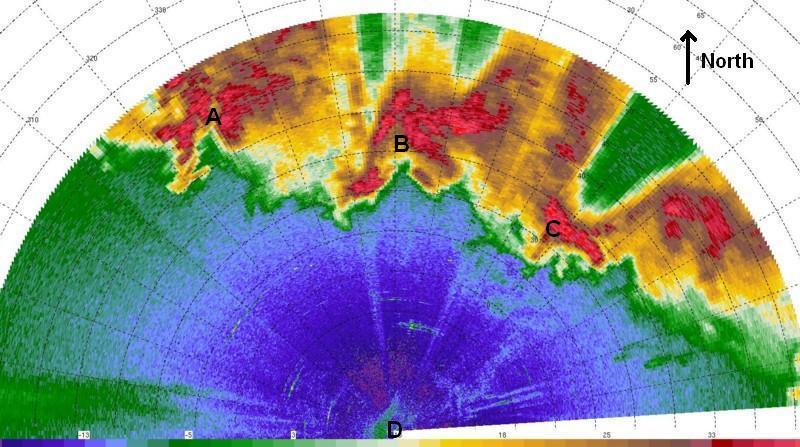
At 5:05 PM CDT when the research team was near Garden City, Kansas (just north of the orange "G" on Fig. 3), the Doppler on Wheels radar observed a band of supercells from 15 to 30 miles to the north of the radar and the storms were moving rapidly towards them (Fig. D1).

A Doppler on Wheels reflectivity
image, used with permission
Figure. D1. The Doppler on Wheels radar reflectivity image observed at 5:05 PM CDT at a location near Garden City, Kansas (just north of orange "G" on Fig. 3). The location of the mobile radar ("D") on this figure is at the center of the range rings (circles of black dots). The top of the image is towards the north. The range rings indicate the distance from the radar. The first ring away from "D" is 6 miles (10 kilometers). Each ring after that is 3 miles (5 kilometers) farther away from "D". The brown, yellow, and red colors are reflected primarily from the storms' precipitation (rain and hail). The red colors depict the most intense precipitation. Supercells with "hook" type signatures are located near "A", "B", and "C".
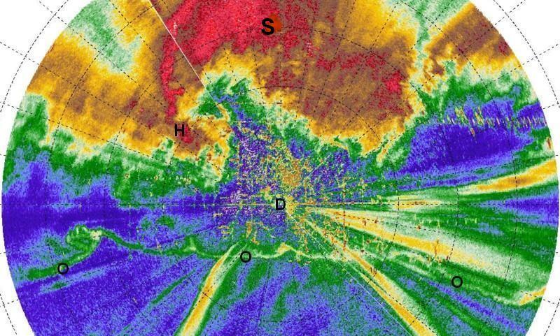
As the band of supercell storms continued to move south southeastward, one supercell approached the mobile radar vehicle and at 5:33 PM CDT it was about 5 to 10 miles north of the Doppler on Wheels (see Fig. D2). By this time the cool and strong outflow winds from this and the other supercells have raced out ahead of the the storms. The leading edge of the outflow winds (gust front) has already passed by the Doppler on Wheels mobile radar's location and can be observed on Fig. D2 as the wavy east-west line (marked by "O" letters). The "hook" echo ("H") associated with the supercell is about 6 miles northwest of the mobile radar and is moving rapidly towards the radar location.

A Doppler on Wheels reflectivity
image, used with permission
Figure D2. Similar to Fig, D1 except blown up in scale and for the time 5:33 PM CDT at a location about 12 miles south of Garden City, Kansas (orange "G" on Fig. 3). One supercell ("S") is just north of the mobile radar with the end of the supercell hook echo indicated by "H". An outflow boundary is indicated by the "O"s.
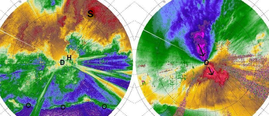
Although the outflow wind gust front was already south of the mobile radar vehicle at 5:33 PM CDT and the research team was experiencing cool and strong northerly outflow winds, the most intense winds were experienced a few minutes later as the supercell "hook" echo moved close to The Doppler on Wheels' location (see Fig. D3). The mobile Doppler radar measured winds exceeding 44 meters per second (98 mph) very near the surface! These winds were coming from the north northwest and are indicated by the magenta (purple) color on the Doppler image to the right on Fig. D3.

Doppler on Wheels reflectivity and Doppler velocity images, used with permission
Figure. D3. On the left is The Doppler on Wheels radar reflectivity image with characteristics similar to Figs. D1 and D2, except for being observed at 5:38 PM CDT near the same location as D2 and being blown up larger in scale than D2 (edge of circular images are about 9 miles from radar location at "D"). On the right is The Doppler on Wheels Doppler velocity image observed at the same time and location as the image on the left. The green, blue, and purple colors represent wind velocities blowing towards the radar, while the yellow orange, brown, and red colors represent wind velocities blowing away from the radar. The strongest winds blowing towards and away from the radar are indicated by the arrows within the colors of magenta (purple) and red.
Back
to the May 27-28, 2001 Case Page
Back to the Derecho Facts Page