JUNE 30 - JULY 1, 2014 DERECHOS
"The 'One-two Punch' Midwest Derechos of June 30 - July 1, 2014"
A pair of derechos dealt parts of the mid-Mississippi Valley
and Great Lakes an unusual "one-two punch" on June 30 - July 1, 2014. The derechos produced swaths of significant wind
damage that extended intermittently from far eastern Nebraska through much of Iowa, northern Illinois, and southern Wisconsin into northern
Indiana and southern Lower Michigan. The most continuous and intense damage occurred over eastern Iowa, northern Illinois, and northern Indiana,
where some locations were affected by both derecho-producing storm systems. The derechos also were responsible for widespread disruption of air
travel through Chicago's O'Hare International Airport. Four million people lost power at some point during the events, and two people
were killed by falling trees. In addition, countless acres of corn and other crops were flattened (Figures 1 and 2).
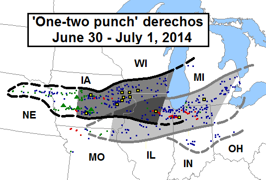
Figure 1. Areas affected (black and gray contours and shading) and storm reports (colored symbols) associated with the dual June 30 - July 1, 2014 derechos. Approximate area affected by first derecho outlined in black; that of the second in gray. Areal outlines dashed to reflect those portions of each event that occurred prior to or after the period of most strongly organized development. The region most impacted by both events shaded in darkest gray. Reports are for the 24-hour period from 7:00 a.m. CDT (1200 UTC) Monday, June 30 to 7:00 a.m. CDT (1200 UTC) Tuesday, July 1. Storm reports depicted as follows: Wind damage or wind gusts ≥ 50 kts (58 mph), small blue squares; estimated or measured wind gusts ≥ 65 kt (74 mph), large black squares with yellow centers; hail ≥ 0.75 inches, small green squares; hail ≥ 2.0 inches, large green triangles; tornadoes, small red squares.
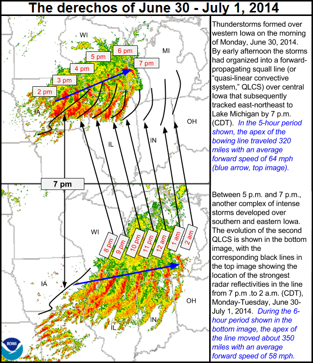
Figure 2. Composite displays of hourly, composite radar reflectivity, showing development and evolution of the two June 30 - July 1, 2014 derecho-producing convective systems. The top image depicts the first squall line (or QLCS, quasi-linear convective system) between 2:00 and 7:00 p.m. (CDT); the bottom image shows the second convective system between 8:00 p.m. and 2:00 a.m. Black lines in top image depict locations of strongest reflectivities associated with the second line. (Modified from base image by G. Carbin, NOAA Storm Prediction Center)
The convective system associated with the first of the two derechos arose from elevated thunderstorms that formed over
northeast Nebraska during the pre-dawn hours of June 30 (Figure 3). Elevated convection frequently is involved in the development
of derecho-producing convective systems. In this case the storms were "elevated" in the sense that they arose within a layer of
instability located above a shallow layer of cooler, more stable air based at the surface. The cooler air had been deposited
by thunderstorms that affected Iowa the previous evening. The early-day Nebraska storms were fed by a band of moist, southwesterly
low-level flow (a "low-level jet stream") that was strengthening downstream from a weak upper-level disturbance crossing the
central Plains ("First disturbance" in Figures 4 and 5). The disturbance was one of several moving eastward within a seasonably
strong (70-80 kt) upper-level jet skirting the northern side of an expansive high-pressure area centered over New Mexico.
The thunderstorms expanded in coverage and intensity as the disturbance continued east-northeastward through the day.
Despite being somewhat removed from the greatest surface-based instability, the Nebraska storms produced damaging surface winds in
addition to large hail. A roof was blown off a home in Winnebego, Nebraska, and two tractor-trailers were flipped south of nearby
Walthill. The storms further intensified through mid-morning as they moved into western Iowa. Hail up to the size of grapefruit
pummelled Rockwell City, Iowa, and baseball-sized stones occurred in Harlan and Fort Dodge. Wind-driven, tennis-ball hail heavily
damaged 300 homes in Adair County (west of Des Moines) and broke car windows along Interstate 80. The very large hail was indicative of
the great degree of instability present aloft, and also reflected that the storms were supercells --- thunderstorms with persistent,
very strong, rotating updrafts.
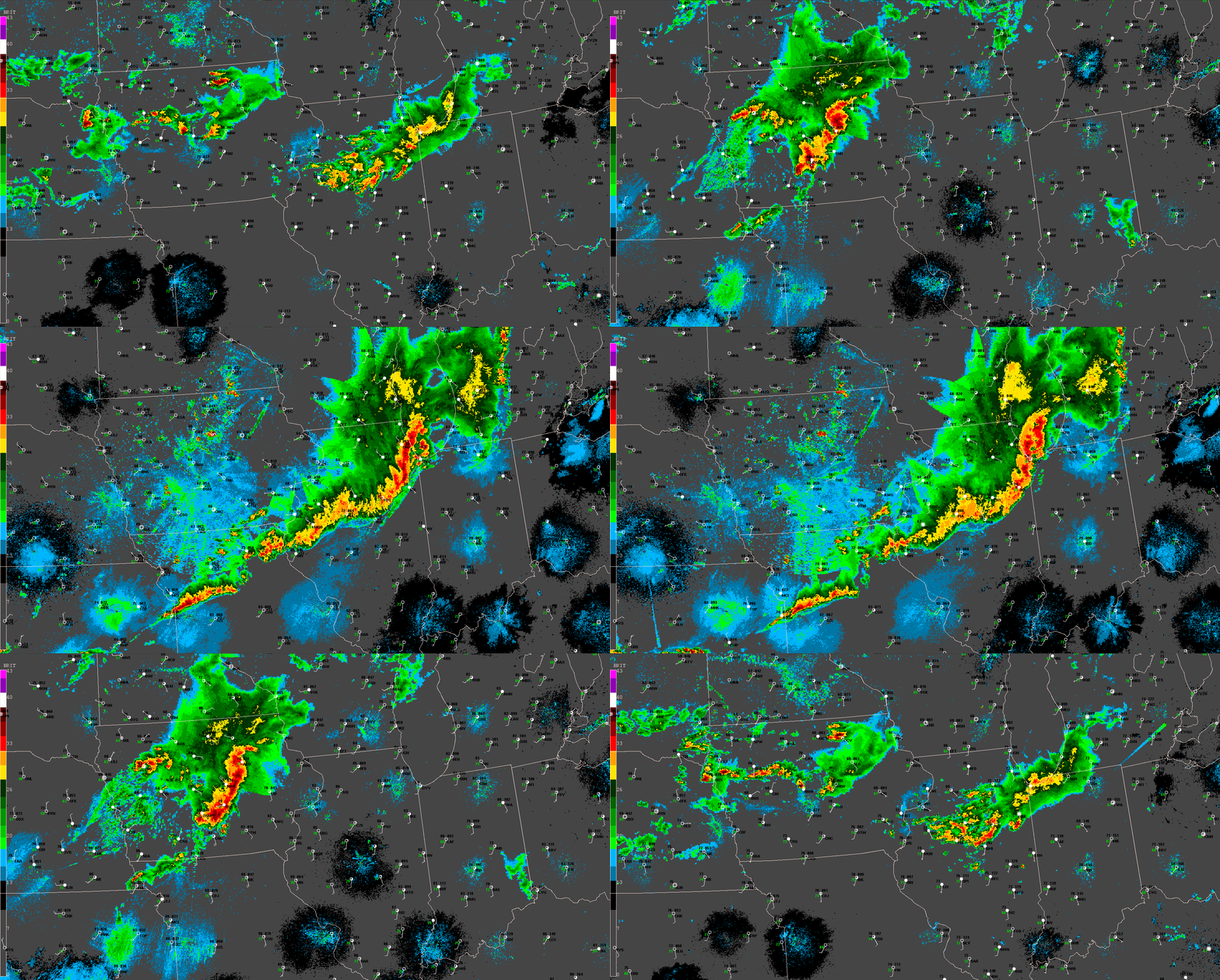
Figure 3. Twenty-two-hour composite radar base reflectivity loop showing development and evolution of the June 30, 2014 derecho-producing convective systems over the Midwest and additional storms that affected the region. "Ping-pong" animation begins at 5:00 a.m. CDT Monday, June 30 (1000 UTC) and ends at 3:00 a.m. CDT (0800 UTC) Tuesday, July 1. Reflectivity intensity scale at left (dBZ). Surface data plotted using conventional format.
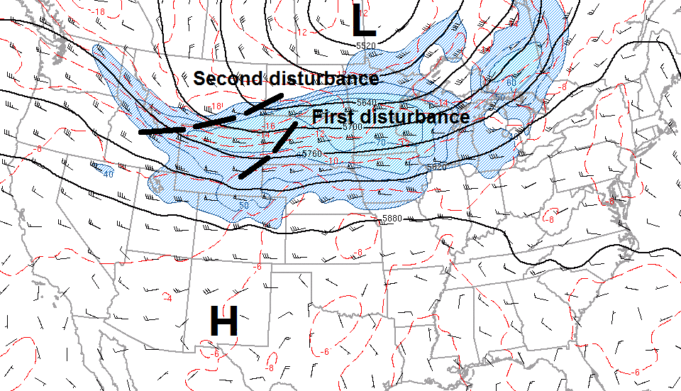
Figure 4. 500 mb (approximately 18,000 ft) analysis for parts of the United States and Canada, 7:00 a.m. CDT (1200 UTC) June 30, 2014, showing elongated area of high pressure ("H") centered over New Mexico, and seasonably strong low ("L") over south-central Canada. Black lines are contours of the 500 mb pressure surface, in meters. Wind flow is parallel to the contours and depicted in the form of "barbs" and "flags;" full barb = 10 kts (1.15 mph); flag = 50 kts (58 mph). Isotachs greater than or equal to 40 kts shown in blue, with hatching. Red dashed lines are isotherms (°C; e.g., -10 = minus 10 °C). Heavy dashed lines mark upper-level disturbances (shortwave troughs) mentioned in the text.
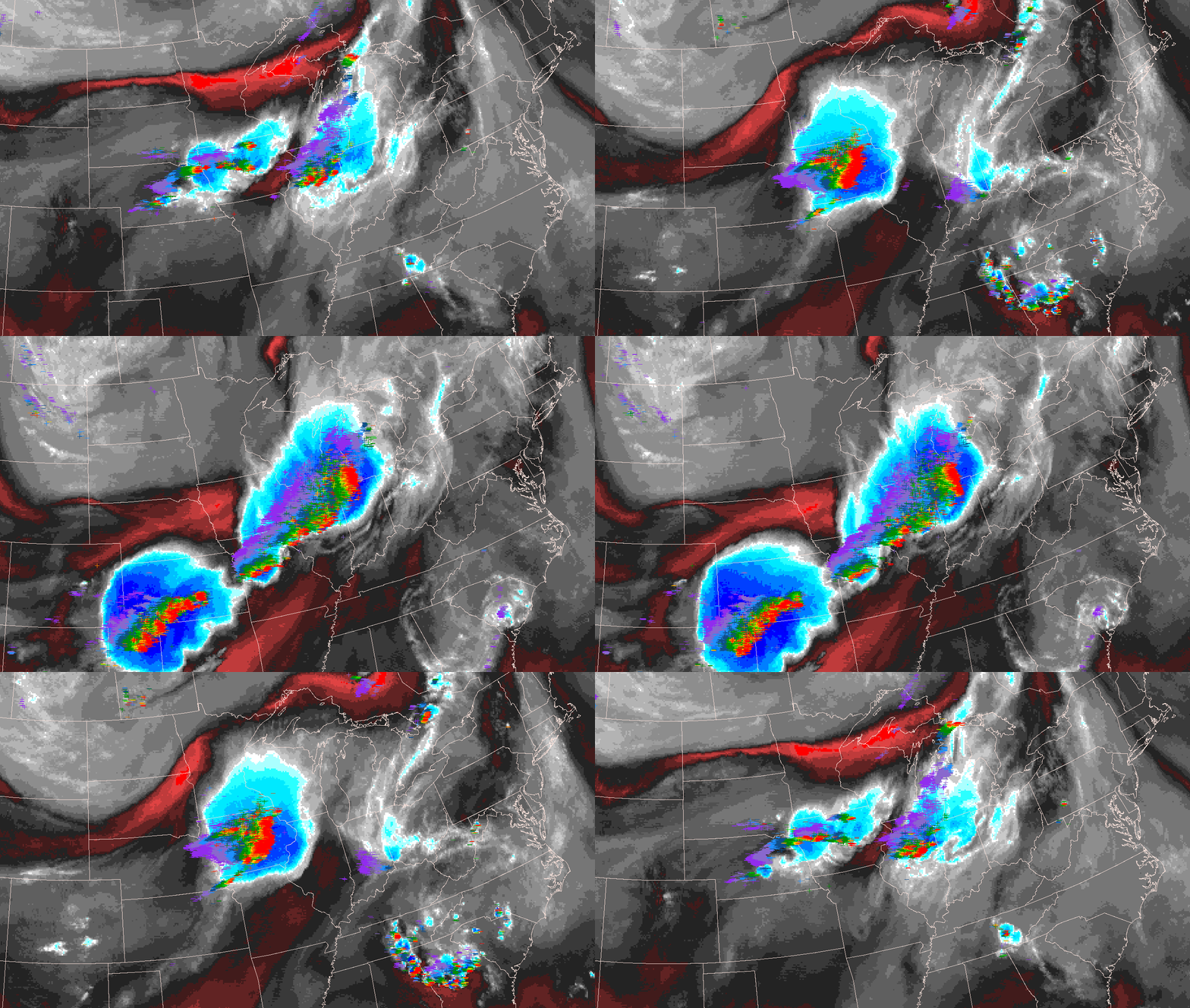
Figure 5. Twenty-three-hour water vapor (satellite) and cloud-to-ground lightning data loop showing the development, evolution, and demise of the June 30, 2014 derecho-producing convective systems. "Ping-pong" animation begins at 5:15 a.m. CDT (1015 UTC) June 30 and ends at 4:15 a.m. CDT (0915 UTC) July 1. Color enhancement scale not shown, but drier areas appear in increasingly bright shades of red, and moist areas in shades of blue and gray. Lightning strikes indicated by "-" and "+" symbols to indicate negative and positive strikes, respectively. Strikes are color-coded by time, with red and orange symbols being the most recent (last fifteen minutes), and blues and purples the oldest (last two to four hours, respectively). Also shown is the development of a separate, more transitory mesoscale storm system that produced locally-damaging winds and hail over the southern High Plains. The loop pauses on selected frames that display the approximate positions of the upper-level (jet stream) disturbances mentioned in the text.
The thunderstorms reached central Iowa around noon (CDT). It was there that they encountered warmer, more moist air spreading northward
as daytime heating partly eroded the shallow cool-air layer at the surface. The storms subsequently underwent a more rapid increase in
number and strength, and evolved into a south-southwest-north-northeast line. The line soon exhibited embedded bowing segments,
particularly in places where supercells had been absorbed within it (Figure 3). These bowing segments, in turn, were associated with
strengthening storm outflow winds.
An 81 mph gust snapped two large trees and flattened corn and bean fields near Hubbard in Hardin County, Iowa, and
partly destroyed a building and house near Martensdale (south of Des Moines). A tractor-trailer also was blown over on Interstate 35 near
Martensdale. Two people were injured when a measured 71 mph gust destroyed business buildings in Fairfax, Iowa (near Cedar Rapids), and
three were injured by falling trees around Iowa City. Farther east, the line assumed a well-defined bow-echo configuration. Storm winds
destroyed a garage and machine shed in Jackson County (south of Dubuque), and overturned a tractor-trailer in neighboring Clinton County.
The storms also produced torrential rains; rainfall rates of 2-3 inches per hour washed out roads and flooded already-saturated farm fields.
Flash flooding claimed at least one death in Cedar Rapids and rainfall totals in some areas exceeded five inches.
The bow reached Illinois and Wisconsin around 4 p.m. Measured 60-70 mph gusts downed trees, power lines, and crops as it surged
east-northeast across northwest Illinois and southern Wisconsin before weakening over the Milwaukee area during the early evening.
The southern part of the bowing convective system, meanwhile, moved somewhat more slowly east across north-central Illinois, producing
largely sporadic damaging gusts and heavy rain. This part of the line did, however, temporarily strengthen as it moved farther east
across the Chicago area around 7:00 pm, and into northwest Indiana and southwest Michigan shortly thereafter, damaging roofs,
power lines and trees.
As the first derecho-producing squall line weakened east of Lake Michigan, a second wind-producing storm system developed over
far eastern Iowa (Figure 3). This line of storms, like the previous one, originated from elevated convection. In this case the
elevated storms formed over southern and eastern Iowa, atop the "bubble" of cool, low-level outflow left by the earlier storms.
Development also was fostered by the approach of a second, more vigorous disturbance in the strong upper-level (jet stream) flow
(Figure 4 and 5), and by uplift along the accelerating cold front tied to that disturbance (note shift of surface winds to northwesterly
across southwest Iowa around the time of the middle pause in the animation of Figure 3).
Early in its development, the second squall line strengthened quite slowly. But the line intensified more rapidly after 8:30 p.m.
as it entered western and northern Illinois. High winds overturned tractor-trailers and damaged buildings in La Salle County (about
50 miles south of Rockford), and a 75 mph gust was measured in the town of Oswego in neighboring Kendall County. Wind damage
increased as the line continued east-southeast across Chicago around 10:00 p.m. An 82 mph gust was recorded at Bolingbrook
(Will County), and a large stained-glass window was blown out of a church in Kankakee. The latter damage likely was associated
with a small tornado embedded within the line of storms. Widespread tree and minor structural damage, in addition to localized
flash flooding, occurred elsewhere across the southern half of the Chicago metro area. Farther south, a tractor-trailer was
blown off Interstate 55 west of Lincoln.
The squall line remained severe as it continued across northern Indiana and southern Lower Michigan after 1030 p.m. (CDT). Just beyond
the Illinois border, storm winds blew the roof off a house and toppled a tractor-trailer near the town of Schneider, Indiana where an
unofficial gust to 86 mph was recorded. Around 1:00 a.m. (EDT), a tree that fell onto a mobile home killed a teenager inside at Winona
Lake, Indiana (west of Fort Wayne). A bit later, a man was killed when a large tree fell through a house on Big Long Lake, Indiana (near
the Michigan border). High winds also caused the partial collapse of a roof and wall at a school in nearby Lagrange, and destroyed a
building near Avon (west of Indianapolis). Sporadic wind damage also occurred across southern Michigan before the storms finally
weakened east of Detroit and over northwest Ohio around 4 a.m. (EDT).
In all, the "One-two Punch" derechos of June 30, 2014 produced more than 300 non-duplicate reports of severe weather from eastern Nebraska
to southern Michigan and northwest Ohio, including nearly two-dozen short-lived tornadoes (path lengths less than ten miles and durations
less than ten minutes). The first derecho tracked from central Iowa to Lake Michigan (a distance of 320 miles) in five hours, with an average
forward speed of 64 mph. The second moved from far eastern Iowa to northwest Ohio and southeast Michigan (a distance of 350 miles) in about
six hours, yielding an average speed of 58 mph. While the tracks of the two wind-producing convective systems slightly differed, their paths
considerably overlapped; parts of Iowa and Illinois experienced derecho winds twice within a several-hour period. Although derechos of similar
size and strength typically affect the Midwest once or twice a year (as seen here), it is unusual
for two derechos to occur in rapid succession --- and for the events to affect overlapping areas. Rapid low-level moisture return in the wake of
the first derecho, and the timely arrival of both stronger flow aloft and increased forcing for ascent with the second upper-level disturbance,
appear to have been responsible for the atmosphere's ability to support two severe squall lines over the same region on a single afternoon
and evening.
_____________________________________________________________________________
Additional information:
Chicago, Illinois NWS Office - The afternoon and evening derechos (June 30) over northern Illinois and northwest Indiana
Des Moines, Iowa NWS Office - Development of the first derecho over central Iowa (late morning - early afternoon, June 30)
Detroit, Michigan NWS Office - Overview of the second derecho as it weakened over southeast lower Michigan (early morning, July 1)
Grand Rapids, Michigan NWS Office - The evening and overnight derechos (June 30 - July 1) over southwest Lower Michigan
Northern Indiana NWS Office - The second derecho over northeast Indiana and northwest Ohio (pre-dawn, July 1)
Quad Cities, Iowa-Illinois NWS Office - Maturation of the first derecho over eastern Iowa and northwest illinois (afternoon, June 30)