JULY 4-5, 1969 DERECHO - FLASH FLOOD
"The Ohio Fireworks Derecho"

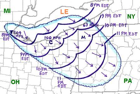
Figure 1. Area affected by the July 4, 1969 derecho (outlined in blue), with the approximate hourly positions of the leading edge of derecho winds (gust front) indicated by curved purple lines. Arrows indicate direction of storm winds.
During the afternoon of Friday, July 4, 1969, thunderstorms formed over southeast Lower Michigan (MI), several of which produced tornadoes, large hail, and high winds west and south of Detroit. As these storms moved southeastward during the early evening, they evolved into a strong derecho over extreme southeastern Michigan (MI) and Lake Erie (LE). The derecho then roared southeast across northern and eastern Ohio (OH) and western Pennsylvania (PA) during the next few hours. The hourly positions of the gust front (associated with multiple bow echoes) are shown in Figure 1 (above). Winds gusted to 104 mph in Toledo ("T"), and reached 100 mph in the Cleveland ("C") area. In towns and cities near Lake Erie, many people were outside, preparing to watch Independence Day fireworks. Also for the occasion, many small boat owners had anchored their craft just off the Lake Erie shore to watch the displays. As the derecho passed, untold thousands of trees were blown down, including 5000 in Toledo alone. Along the south shore of Lake Erie, eight people were killed by falling trees and over 100 boats were overturned, drowning at least three persons. A total of eighteen people were killed as a result of the derecho winds in Ohio. Some of the worst damage occurred in Lakewood, a suburb of Cleveland. The storm system continued to uproot trees, damage roofs, and produce power outages as it moved into Pennsylvania, where five people were injured by high winds in Meadville ("M").
A 3-cm Decca-brand local warning weather radar located in Akron, Ohio observed a bow-shaped echo about 35 miles northwest of the radar site at 8:30 PM on the evening of July 4th (Figure 2). This bow echo was associated with the deadly derecho winds in Cleveland, and was one of the first radar-documented "bows." Shorter wavelength radars such as the 3-cm Decca unit were used in the pre-Doppler (WSR-88D) radar era to supplement observations in areas farther removed from the Weather Bureau's WSR-57 10-cm radar sites. The image also shows a LEWP (line echo wave pattern) that marks the intersection of the main bow echo (representing the most rapidly-moving part of the squall line) with the somewhat more slowly-progressive part of the line farther east. A small-scale (sub-synoptic) low pressure area was centered at the crest of the LEWP. A discussion of the low and its associated radar structures appears in in Hamilton 1970.
Figure 2. Radar reflectivity at 8:30 PM EDT July 4, 1969, as depicted by a Decca (brand name) 3-cm, local weather warning radar located near Akron, Ohio. The image was made from an original Polaroid photograph taken by G. Vaughn. The intersection of the two arc-shaped reflectivity structures marks the center or inflection point of the LEWP mentioned in the text.
As the derecho-producing convective system continued southeastward overnight, winds over northern Ohio in the wake of the bowing segment remained northwesterly through much of the atmosphere, while an inflow of very warm, moist air from the west persisted at the surface. As a result, trailing portions of the convective system's outflow became nearly stationary along a northwest-to-southeast axis from southern Michigan into northern Ohio, much as described in Derechos and Flash Floods, and as shown schematically in Figure 3 (below). Strong thunderstorms subsequently "trained" along and east the outflow boundary for several hours through the early morning of July 5th. The repetitive storms unleashed a deluge that included nine inches of rain in less than fifteen hours in Wayne County, Ohio (southwest of Akron), and nearly fifteen inches near Wooster. In neighboring Holmes County, Killbuck Creek crested more than 20 feet above normal level, nearly completely inundating the town of Killbuck. Flash flooding and dam breaks in northern Ohio alone claimed more than two dozen deaths.
Figure 3. Hourly sequence of smoothed radar reflectivity, based on hand-drawn sketches made from the Pittsburgh, PA WSR-57 radar data that appear in Hamilton 1970. Subjectively-analyzed outflow boundaries depicted by conventional frontal symbols. The two reflectivity levels shown loosely correspond to "heavy" (green, VIP level-4) and "intense" (yellow, VIP level-6) WSR-57 calibrated echo strength. Cross symbol in the 0100 UTC (2100 EDT) image marks approximate location of the line-echo wave pattern (LEWP) shown in Figure 2. Three-letter airport IDs denote locations mentioned in the text (Akron, OH (AKO), Cleveland, OH (CLE), Detroit, MI (DTW), Pittsburgh, PA (PIT), and Toledo, OH (TOL)).
With total storm damage from high winds and flooding in Ohio estimated to have been more than $65 million (1969 dollars), and with a death toll in excess of 40, the July 4-5, 1969 derecho-producing convective system remains one of that state's most costly and deadly ever. The comparatively brief description here given reflects only the event's relatively distant place in time. Given the nature and magnitude of the storm, the Independence Day 1969 derecho-flash flood is deserving of a more comprehensive presentation were the relevant meteorological data (e.g., animated radar and satellite imagery) readily available. An excellent discussion of this event from the perspective of an eyewitness boating enthusiast in Cleveland appeared in the July 1970 issue of Boating magazine, and is available here
_____________________________________________________________________________
Additional information:
Hamilton 1970
Storm Data, July 1969


