
JULY
4-5, 1999 DERECHO
"The Boundary Waters - Canadian Derecho"

Figure 1. Area affected by the July 4-5, 1999 derecho event (outlined in blue). Curved purple lines represent the approximate locations of the gust front at three-hourly intervals. "+" symbols indicate the locations of wind damage or estimated wind gusts above severe limits (58 mph or greater). The other symbols are described in the text below.
During the pre-dawn hours on Sunday, July 4, 1999 thunderstorms were occurring over portions of the Dakotas. By 6 a.m. CDT some of the storms formed into a bow echo and began moving into the Fargo, North Dakota area with damaging winds. Thus would begin the "Boundary Waters - Canadian Derecho" that would last for over 22 hours, travel over 1300 miles at an average speed of almost 60 mph, and result in widespread devastation and many casualties in both Canada and the United States (Figure 1). The following paragraphs describe what happened along the path of this long-lived international derecho.
...NORTH DAKOTA...
As the bow echo system formed over eastern North Dakota (ND) on the morning of July 4th, it quickly started to produce very severe, long-lasting winds. The storm winds reached Fargo's Hector Airport around 7:30 a.m CDT. Winds in excess of 58 mph continued for 39 minutes, and a maximum gust of 91 mph was measured at 7:42 a.m. Many planes at the airport were damaged or overturned, and hangers were damaged as well. In the Fargo metropolitan area, damage totaled more than $85 million (1999 U. S. dollars). Many roofs were damaged or blown off, and some buildings and garages were destroyed. Vehicles were damaged or overturned, and many trees and power poles were blown down. About 40,000 customers were without electrical power. Several people were injured.
Figure 2 provides a radar view of the developing bow echo and its entry into western Minnesota.
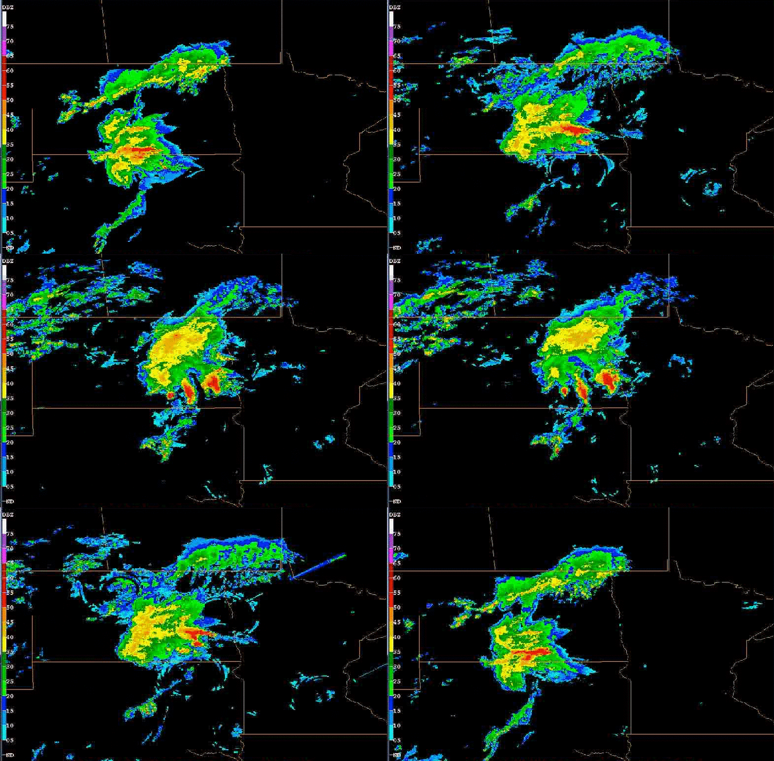
Figure 2. Two-hour "ping-pong" animation of composite base reflectivity radar data showing early morning development of the July 4, 1999 derecho-producing bow echo system over southeast North Dakota. Reflectivity intensity scale at left (dBZ). (Data provided by Peter S. Parke and Norvan J. Larson, NWS Duluth)
...MINNESOTA...
Severe wind damage continued to occur as the derecho moved across central and northern Minnesota (MN). The roof was blown off the public works building in Ada, and many buildings, mobile homes, and vehicles were damaged by the derecho winds and falling trees in Clay, Norman, Hubbard, and Beltrami Counties. Damage in Cass, Itasca, and Aitkin Counties exceeded three million (1999 U. S. dollars), and several campers were injured in the Walker-Leech Lake area. As the derecho entered St. Louis County, a wind gust of 81 mph was recorded at the Chisholm-Hibbing Airport, and the terminal building and hanger suffered damage. A semi-trailer truck was blown over on U.S. Highway 53 near Canyon, Minnesota, just northwest of Duluth.
As the derecho raced into the Arrowhead region of northeast Minnesota during the early afternoon of July 4th, many casualties occurred despite the low population density of this heavily forested area. Because it was Independence Day weekend, many people had travelled to the Boundary Waters Canoe Area (BWCA) to enjoy canoeing and camping. Winds estimated at 80 to 100 mph moved rapidly through the area, causing serious damage to 600 square miles of forest in the Arrowhead region. Tens of millions of trees were blown down (Figures 3 and 4). Sixty people in the BWCA were injured by falling trees, some seriously. Twenty of those injured were rescued by float planes flying to lakes located in the forest near the victims. Figure 5 shows the bow echo moving across northern Minnesota as viewed by radar.
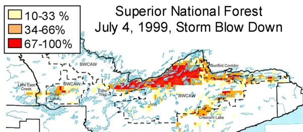
Figure 3. Percentage of trees blown down in Superior National Forest in northeast Minnesota on July 4, 1999. Scale: 1" = 15 miles. (Courtesy of USDA Forest Service, Superior National Forest)
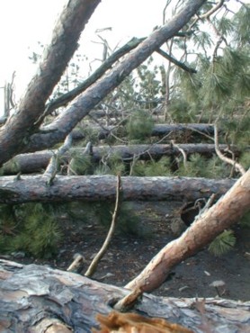
Figure 4. Trail in the Boundary Waters Canoe Area blocked by fallen trees. (Courtesy of USDA Forest Service, Superior National Forest)
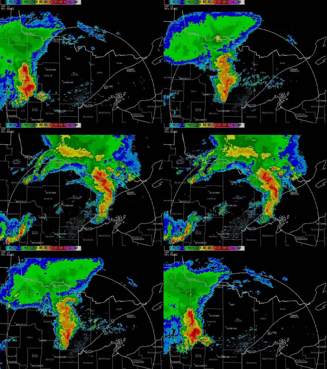
Figure 5. Four-hour "ping-pong" animation of NWS Duluth base reflectivity radar data showing progress of the July 4, 1999 derecho-producing bow echo system across north central Minnesota through midday, and its subsequent movement across the "Arrowhead" region during the early afternoon. Reflectivity intensity scale at left (dBZ).(Base data provided by Peter S. Parke and Norvan J. Larson, NWS Duluth)
Other information (including photos and a video) on the July 4-5, 1999 derecho and its effect on the Boundary Waters Canoe Area of northeast Minnesota was once available at the following web sites linked below. However, as of March 2014, these links were no longer active, and updated URLs could not be found. The links will nevertheless remain posted in the belief that those interested in further information might want to contact the respective agencies involved on their own behalf:
Blowdown in the Border Forest ..................................................Science
Museum of Minnesota
Blowdown
storm recovery information .......................................Superior National Forest,
U.S. Forest Service
Boundary
Waters blowdown .......................................................Minnesota Dept.
of Natural Resources
Boundary Waters wind storm of July 4, 1999 .............................Duluth, Minnesota NWS
Forecast Office
Video
on the July 4, 1999 derecho .............................................American Museum of
Natural History
...ONTARIO...
As the derecho entered Ontario (ON) during the early afternoon of July 4th, serious forest blowdowns continued, with some of the worst damage extending from the southeast corner of Quetico Provincial Park east to the area around Arrow Lake. As the derecho moved farther east, it began to affect more of the northern portion of Lake Superior (LS). Environment Canada's automated weather station on Trowbridge Island near the southeast corner of Thunder Bay recorded a gust to 115 kph (71 mph) as the bow echo gust front moved across the area. However, the winds over the open waters of Thunder Bay and adjacent portions of Lake Superior were estimated to have been much stronger, possibly greater than 160 kph (100 mph). Many boaters on and near Thunder Bay ("T" in Figure 1) were besieged by these intense derecho winds. In his book Wake of the Green Storm, Marlin Bree describes his and other boater's close calls in surviving the fierce winds and huge waves as the storm roared through. One sailboat was overturned and two people were thrown into the cold water. Fortunately, a nearby boater was able to rescue them before the water took its toll.
From the
northeast shores of Lake Superior (LS) to the western border of Quebec (QC),
the derecho continued to topple many trees as it raced across the heavily forested
and sparsely populated region of northern Ontario at a speed of almost 60 mph
during the evening of July 4th. The main line of the Canadian Pacific
Railroad was closed between White River and Chapleau (dashed line in Figure
1) because of fallen trees blocking the tracks. In nearby Chapeau Park Game
Reserve, many trees were blown down at a resort on Lake Wabatongushi ("R"
in Figure 1), with the severe derecho winds lasting for 20 minutes. Forest blowdowns
also were reported in areas south of Timmins ("F" symbols in Figure
1).
...QUEBEC...
[The description of the derechos effect in Quebec was obtained from Environment Canada, Technical Note, Quebec Region, 99N-04 by Serge Mainville. The radar and satellite imagery (Figures 6 and 7 and the movie loops) were provided by McGill University and Environment Canada meteorologist Pierre Vaillancourt.]
The derecho-producing bow echo system, racing east southeastward at a speed of nearly 100 kph (62 mph), entered the Temiscamingue region of Quebec (QC) by late Sunday evening on July 4th (Figure 6). A gust of 100 kph (62 mph) was measured at Temiscaming, and a gust of 105 kph (65 mph) was measured at Angliers, with electrical power outages occurring in the region. There also was a tremendous amount of cloud-to-ground lightning associated with the bow echo thunderstorms, with up to 6000 strikes per hour.
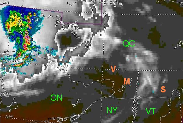
Figure 6. Radar reflectivity (bright colors) superimposed on satellite image (storm system cloud tops in shades of gray), showing the derecho-producing bow echo system entering southwest Quebec at 10:45 p.m. EDT on Sunday, July 4, 1999. Click here to see an animation of this composite imagery, showing the bow echo system moving across Quebec and into northern New England. Figure 6 also has been modified to show the symbols for provinces and states (in green), and the locations of towns and cities discussed below (in orange).
As the derecho tracked across southern Quebec during the early morning of Monday, July 5th, farm buildings were damaged and many trees uprooted from the Maniwaki area to Mt-Tremblant Park and areas to the south. At Val-des-Lacs near St-Jovite (orange "V" in Figure 4), falling trees killed a camper and injured a woman by crushing her car.
The derecho gust front with wind speeds ranging from 85 to 120 kph (55 to 75 mph) moved into Montreal (orange "M" in Figure 6) and the surrounding region around 2 to 3 a.m. EDT. In the Montreal area, falling trees damaged cars and roofs. At the St. Lawrence River docks in Pointe-Claire, fifteen boats were overturned. East of Montreal, farm buildings were damaged in Vaudreuil-Soulanges and Beloeil. In St-Hyacinthe, roofs were damaged and windows were blown out in the upper stories of a hotel.
Figure 7 shows the Doppler wind speeds as measured by the McGill (Montreal) radar at 2:45 a.m. EDT when the derecho gust front was located just east of Montreal. The radar (black "R" in Figure 7) is located about 20 kilometers (12 miles) west southwest of downtown Montreal. The derecho gust front is near the leading edge of the curved purple band. The strongest wind speeds, moving directly away from the radar, are in dark purple. This band represents speeds of 30 to 40 meters per second (110-145 kph or 65-90 mph).
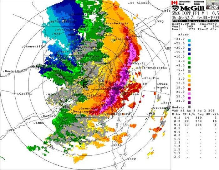
Figure 7. Doppler wind speeds recorded by the McGill radar (black "R" at center of the rings) at 2:46 a.m. EDT on July 5, 1999. Winds blowing toward the radar are in shades of green and blue; winds blowing away from the radar are in shades of yellow, orange, red, and purple. With increasing distance from the the radar, the wind speeds observed are made at increasing elevations above the ground. Additional information from the McGill radar concerning the derecho producing bow echo system's characteristics may be seen here.
The derecho roared through the Eastern Townships between 3 and 4 a.m. EDT with measured gusts to 105 kph (65 mph) at Lennoxville and 114 kph (71 mph) at the Sherbrooke Airport. In the city of Sherbrooke (orange "S" in Figure 6) numerous trees were uprooted (Figure 8), and numerous roofs and cars were damaged by falling trees. Also, St. Andrew Church in downtown Sherbrooke was badly damaged with a part of the roof destroyed and one of the brick walls collapsed (Figure 9). Southeast of Sherbrooke in the Sawyerville, Martinville, and Johnville communities, farm buildings were damaged and one tree farm had most of its 2000-3000 trees destroyed. Hydro-Quebec reported that from the Montreal area into the Eastern Townships 600,000 customers lost electrical power, some for over a week.
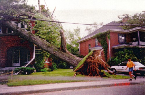
Figure 8. One of the 200 year-old trees uprooted in the old north town part of Sherbrooke, Quebec (facing south) (From Mainville 1999)
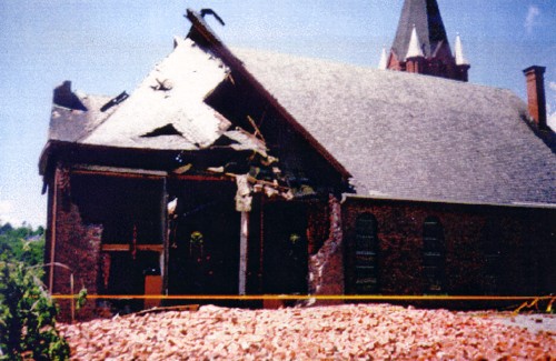
Figure 9. East side of damaged St. Andrew Church in downtown Sherbrooke, Quebec, with remains of brick wall downwind. (From Mainville 1999)
After passing through southern Quebec, the derecho crossed the international border for a second time, entering northern New England in the pre-dawn hours of July 5th. Thousands of trees were blown down, several buildings damaged, and about 26,000 customers lost electrical power. A wind gust to 90 mph was measured near Colebrook, New Hampshire (NH).
While crossing northern New England the derecho caused several casualties. In Vermont (VT), a camper drowned in Lake Salem in Orleans County when the tent they were sleeping in was blown into the lake. The tent had been placed on a raft, and the camper became entangled in the submerged tent. In New Hampshire, three people in campgrounds in Errol were injured by falling trees. In Maine (ME), two campers were injured in Coburn Gore when a large tree limb fell on the tent in which they were sleeping. Just south of Coburn Gore, other campers experienced the destructive derecho winds, and one of them has an interesting story concerning her experience.
Sarah Jamison, a National Weather Service meteorologist who was an intern at the Portland/Gray Maine office at the time, was enjoying the 4th of July 1999 holiday weekend camping and celebrating with family members and friends in the Rangeley Lakes region of western Maine (red "X" in Figure 1). July 4th was a very hot and humid day, with a high temperature near 90. Although conditions were oppressive, Sarah, along with her family and friends, enjoyed the day swimming, boating, and relaxing in the shade. As the Independence Day celebration came to an end, sleeping arrangements were made for the night at their campsite near the shore of Cupsutic Lake. Sarah's mother and father would sleep on their boat near the docks, her brother would sleep in their sport utility vehicle (SUV), and Sarah and her friends would share a tent.
As the night progressed, Sarah mentioned that "the air was very stagnant with no wind, making it very uncomfortable in the hot tent". Sarah and her friends were having trouble sleeping, so at about 3 a.m. she and a friend left the tent to get some fresh air. They noticed lightning in the distance and returned to the tent, zipping up the flaps to keep the anticipated rain from getting things wet.
In the meantime, Sarah's mother also had awakened. She became concerned by the amount of lightning she was seeing to the northwest as the storm approached. As she left the boat to warn Sarah and her friends about the approaching storm, the gust front hit and the wind markedly increased. She ran about 20 to 30 yards from the boat to Sarah's tent. Once she reached it, she yelled for Sarah and her friends to get out of the tent, but the roar of the winds was so loud that they were at first unable to hear her. Finally, her mother was able to get their attention and the two jumped out of the tent. They all then ran to the SUV where Sarah's brother was sleeping. Unfortunately he slept with the doors locked, so it took some time to get his attention. By the time he was able to unlock the door, the first tree had fallen in the campsite. Given that experience, everyone quickly jumped into the SUV. Before the doors were closed, a much larger tree was uprooted and landed on the tent. Once everyone was inside the vehicle, they could see trees falling all around with every lightning flash. The roar of the storm's winds was so loud that none could recall actually having heard the trees snapping or falling on the ground. After about five minutes the winds began to weaken, and within a half-hour the storm had passed. Fortunately, no one in the group was hurt. However, if Sarah's mother had not recognized the danger or had been a minute or two later arriving at the tent, the outcome would have been much worse.
As often is the case with derechos, the damage that hit Sarah's campground was associated with a narrow band of intense, very damaging downbursts embedded in a broader swath of strong but less severe winds produced by the parent convective system. The most significant damage in the area extended from Sarah's campsite and those adjacent to hers to an island in the lake, where every tree was snapped or uprooted. In Sarah's and the two adjacent campsites, about two dozen trees were blown down, several of which were larger than two feet in diameter. One of these large trees and two smaller ones had fallen on Sarah and her friends' tent, completely crushing it. In Sarah's opinion it would have been impossible for them to have survived if they had remained in the tent during the most intense part of the storm.
After leaving the Cupsutic Lake campground, the derecho continued to cause damage across central and southern Maine. Finally, after traveling over 1300 miles, the bow echo system weakened and the derecho ended just before reaching the Atlantic coast.
...SUMMARY...
The very long-lived Boundary Waters-Canadian Derecho was one of farthest north "progressive" derechos to have been recorded. It traveled through a large part of the boreal forests of North America, uprooting and breaking off hundreds of square miles of trees. Two people were killed and 70 were injured. Almost all of the casualties (67) were the result of trees or tree limbs falling on the victims. Additionally, almost all of the victims were outdoors (e.g., camping, hiking, or canoeing). This includes one casualty that was not the result of a falling tree (or limb); this person's death was due to drowning after having been blown off a boat. Drownings are another cause of death most frequently associated with warm-season derechos.
Most of the damage to homes and businesses occurred in areas of higher population density such as near the beginning of the event in the Fargo, North Dakota metropolitan area, and near the end of the event over parts of south central and southeast Quebec (Figure 1). It was these areas that contributed the most to the recorded property damage that exceeded $100 million in 1999 U.S. dollars --- and to the total of over 700,000 households and businesses that lost electrical power from the long-lived derecho.
_____________________________________________________________________________
[Data and other information on the July 4-5, 1999 derecho in Ontario and Quebec were provided by Environment Canada meteorologists Phil Chadwick, Rene Heroux, Michael Leduc, Serge Mainville, and Pierre Vaillancourt.]
Additional information:
Mainville 1999
Miller and Johns 2000
Price and Murphy 2002
Storm Data, July 1999
Wake of the Green Storm, by Marlin Bree
Back to Noteworthy Derechos list
Back to Types of Derechos question