April 4-5, 2011 DERECHO
"The Southeast U.S. 'Derecho' of April 4-5, 2011"
Several broken bands of thunderstorms
formed over east Texas, Arkansas, and southeast Missouri on the morning of Monday, April 4, 2011, along and ahead of a
cold front that trailed southwestward from a deepening surface low over lower Michigan. By early afternoon, the storms
had evolved into an extensive squall line that spanned nearly the entire length of the front from Ohio southwestward into
Mississippi and Louisiana (Figure 1). The convective system moved steadily east in the form of a serial derecho through
the remainder of the day, blasting the Gulf Coast states and the lower Ohio and Tennessee valleys with broad swaths of
damaging wind and nearly four dozen tornadoes (Figure 2). Despite the loss of daytime heating, the squall line remained
strong through the night, reaching the Atlantic coast around sunrise on Tuesday, April 5. In total, a record number of 1266
severe weather reports were recorded, including nearly 1100 instances of damaging wind. While most of the observed gusts
were below official severe limits (58 mph or 50 kts), the event nonetheless caused several wind-related deaths, at least 30
injuries, and was noteworthy for both its breadth and duration.
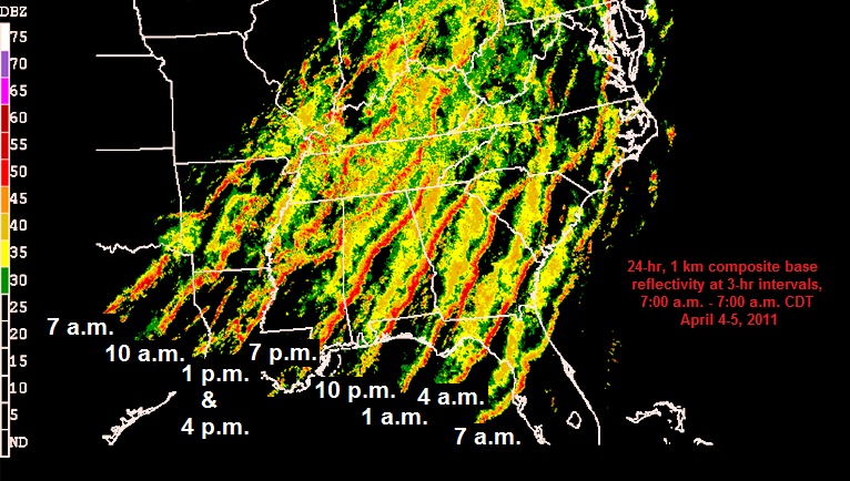
Figure 1. Composite display of hourly radar reflectivity imagery, showing development and evolution of the April 4-5, 2011 derecho-producing convective system. Time (CDT) ranges from 7:00 a.m. Monday, April 4 (1200 UTC April 4, far left) to 7:00 a.m. Tuesday, April 5 (1200 UTC April 5, far right). Intensity scale (dBZ) at left. (Modified from base image by G. Carbin, NOAA Storm Prediction Center)
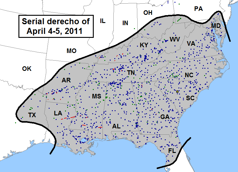
Figure 2. Approximate area affected (black contours surrounding gray shading) and storm reports produced (wind, blue squares; estimated or measured wind gust ≥ 65 kts (74 mph), large black square with yellow center; hail, green squares; tornadoes, red squares and tracks) by the serial derecho of April 4-5, 2011 over the southern and eastern United States. Reports are for the 24-hour period from 7:00 a.m. CDT (1200 UTC) Monday, April 4 to 7:00 a.m. CDT (1200 UTC) Tuesday, April 5.
The April 4-5, 2011 derecho formed in an environment that was more or less typical of those associated with spring
serial-type derechos (see Types of Derechos) over the southern and eastern United States.
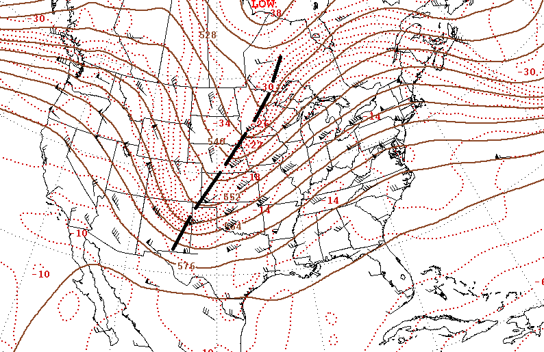
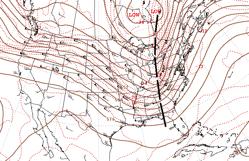
This environment included an amplifying, but progressive "full latitude" shortwave trough (i.e., one having substantial latitudinal
extent), with 500 mb wind speeds in excess of 75 knots (Figure 3). The trough was preceded by a seasonably strong surface low and
cold front. High temperatures in the warm sector east of the front prior to the derecho reached the mid-80s (°F) as far north
as Des Moines, Iowa and Quincy, Illinois on Sunday April 3. However, as frequently is the case in situations of this type,
pre-frontal low-level moisture, while adequate for the development of storms, was not excessive; surface dewpoints averaged in
the mid 50s to mid 60s (°F), with the highest values near the Gulf Coast (Figure 4). The relative paucity of warm sector moisture,
however, likely aided thunderstorm development by minimizing mixing-type (stratocumulus) cloud cover, thereby allowing for
maximal diurnal steepening of low-level lapse rates.
The composite outflow boundary left by strong thunderstorms that formed along the cold front over parts of the central Plains and
mid-Mississippi Valley on the evening of April 3 reached a northwest Ohio to northeast Texas line by sunrise April 4. Storms
persisted within this corridor through mid-morning, producing numerous instances of downed trees and power lines, and scattered
structural damage, especially in Arkansas and Texas. One man was hospitalized in Pine Bluff, Arkansas, after having been hit by a
flying tree limb, and a tornado that was rated EF2 injured two people near Blevins, Arkansas. In far western Kentucky, people
temporarily were trapped in a collapsed building in Ballard County. But the derecho did not begin in earnest until around midday on
the 4th as the remnants of the overnight storms, together with new activity that formed in response to daytime heating, merged
to form a convoluted but nearly solid line of thunderstorms extending from western Ohio to central Louisiana (Figure 4).
|
|
Figure 3. 500 mb (approximately 18,000 foot) upper air analyses for part of North America valid 7:00 a.m. CDT (1200 UTC) April 4 (left) and April 5 (right), 2011. Brown lines are contours of the 500 mb pressure surface, labeled in decameters (e.g., "576" = 5,760 meters or 18,900 feet). Wind flow is parallel to the contours and depicted at radiosonde observation sites in the form of black "barbs" and "flags;" full barb = 10 kts (1.15 mph); flag = 50 kts (58 mph). Thin dashed lines are isotherms (°C; e.g., -10 = minus 10 °C). Heavy dashed lines over the upper Mississippi Valley/Central Plains on April 4 and the Ohio Valley/Southeast on April 5 mark axis of the upper-level trough mentioned in the text. (Base map courtesy of NOAA-NWS-NCEP Weather Prediction Center)
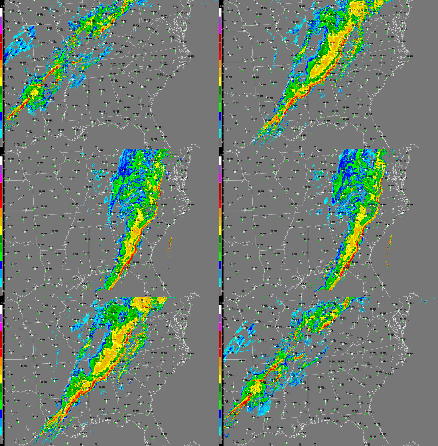
Figure 4. 24-hour composite radar base reflectivity loop showing development and evolution of the April 4-5, 2011 derecho-producing convective system. "Ping-pong" animation begins at 7:02 a.m. CDT (1202 UTC) Monday, April 4 and ends at 6:56 a.m. CDT (1156 UTC) Tuesday, April 5. Loop pauses at 11:48 a.m. (1648 UTC) and 3:56 p.m. (2056 UTC) to highlight development of transient LEWP structures. Surface data also shown, using conventional format with standard three-letter station identifiers (temperature / dew point (°F) on left, pressure / pressure tendency (mb) on right; white lines / barbs depict wind direction and speed (knots; one full barb = 10 knots = 11.5 mph)). Reflectivity intensity scale at left (dBZ).
Serial-type derechos frequently include embedded line echo wave patterns or "LEWPs."
While the storms associated with the April 4-5, 2011 derecho never assumed well-defined LEWP configurations, the first of two
weakly-organized LEWPs that did form evolved over eastern Arkansas, west Tennessee, and western Kentucky around noon Central time (Figure 4).
In the Memphis area, storm winds blew out windows at St. Francis Hospital in Germantown and gusted to 56 kts at Memphis International Airport,
producing widespread power outages. Tractor trailers were overturned by high winds in middle Tennessee and northern Mississippi, and steel power poles
were bent near Nashville. Farther north, a manufacturing plant was hit by an EF2-rated tornado associated with the LEWP near Hopkinsville in
southwest Kentucky. Seven people were injured by flying debris as parts of the building's walls and roof collapsed.
A broad, nearly continuous swath of wind damage continued eastward across much of the remainder of Kentucky, Tennessee, Mississippi and
northern Alabama before the LEWP weakened upon reaching southern Ohio, West Virginia and far eastern parts of Kentucky and Tennessee. Although
most of the damage was confined to downed trees and power lines, trailers were blown over in south central Kentucky, and two people were injured
when a concrete-wall garage collapsed just across the Tennessee border near the town of Celina.
A second loosely-organized LEWP arose during the mid-afternoon over Louisiana and Mississippi (Figure 4). This feature continued east-northeast
across parts of the lower Mississippi and Tennessee valleys later in the day, reaching northwest Georgia around sunset. While this southern
extension of the larger derecho-producing squall line encountered a more moisture-rich environment than did the portion that affected the Ohio Valley
(average surface dewpoints in the mid 60 °F vs. the mid 50s), the mean flow was weaker relative to points north (approximately 50 mph vs. 80 mph;
Figure 3). Nevertheless, the environment proved suitable for embedded supercells and other rotating structures within the largely linear convective
band. As a result, in addition to producing high winds that caused widespread tree, roof, and power line damage across much of Louisiana, central
and southern Mississippi, Alabama, and the Florida Panhandle (including several deaths and injuries from falling trees), the storms also spawned
occasional tornadoes. In Louisiana, an EF2 tornado overturned a tractor trailer and nearly destroyed a water treatment plant near St. Joseph.
Several other tornadoes touched down elsewhere in Louisiana and Mississippi through early evening with more minor damage. However, an isolated
tornado that occurred later in the night as the squall line crossed south central Georgia killed one person and injured two others as it
destroyed a trailer home near the town of Eastman shortly after 1:00 a.m. (Eastern time).
The convective system continued steadily east across the remainder of Georgia, northern Florida, and the South Carolina and North Carolina piedmont
and coastal plain through the early morning of Tuesday, April 5, continuing to produce widespread damaging wind. During this time the squall
line also developed northward into central portions of Virginia and Maryland, where it intercepted a corridor of low-level moisture spreading north
along the east slopes of the Appalachians. Despite the unfavorable time of day, the swath of damaging wind, including a couple brief tornadoes,
expanded north to include the Chesapeake Bay area and Delmarva Peninsula.
As previously mentioned, the April 4-5, 2011 derecho was responsible for a record number (1096) of non-duplicate damaging wind reports in a 24-hour
period. Yet, as shown in Figure 5, only six officially observed wind gusts meeting the National Weather Service definition
of "severe" (greater than or equal to 50 kts (58 mph)) were recorded, and only one "significant" (65 knots (75 mph) or greater) gust was
observed --- despite the relatively high density of observing sites in the path of the storm. This illustrates one of the difficulties involved in using
wind reports alone to place a given derecho in historical perspective, or to assess its meteorological significance. Because of the many trees and
man-made structures present over the southern and eastern United States relative to some parts of the country (e.g., the Rockies and northern Plains),
and because of the sizable population density in those regions, the southern and eastern states are especially vulnerable to the hazards posed by derechos.
But does this mean that derechos necessarily are more common there?
The April 4-5, 2011 derecho spanned a distance of about 800 miles in 24 hours, giving it an average forward motion of 30-40 mph. This forward speed is
well below that of the mid-tropospheric flow (Figure 3), and also less than that of nearly every other derecho presented in About Derechos. The fact
that, in contrast to most derecho-producing convective systems, the April 4-5, 2011 squall line moved more slowly than the mean cloud-layer wind
(approximately 50 kts or 58 mph) rather than outpacing it suggests that the physical processes involved in the system's development and
maintenance may have differed somewhat from those associated with most other widespread damaging convective wind events (e.g., see
this paper for discussion on the processes by which convective systems
can move faster than the mean flow). The April 4-5, 2011 derecho was, nevertheless, significant from a sociological point-of-view. Events like this
therefore call into question the very definition of the term "derecho," suggesting that a more physically-based definition should be adopted by
the meteorological community to better reflect the range of atmospheric conditions and processes that can yield organized convective wind storms.
They also highlight the fact that non-meteorological factors can influence the human impact of a given weather system as much as meteorological ones.
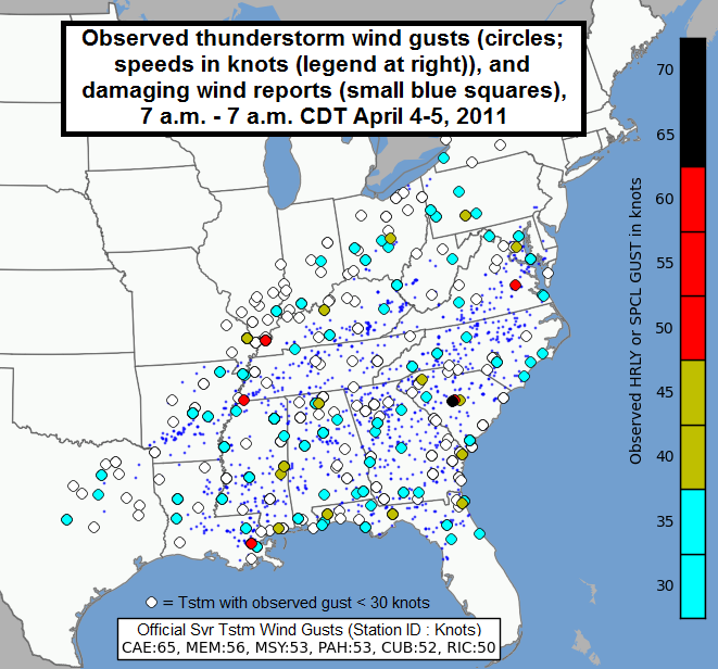
Figure 5. Officially observed thunderstorm wind gusts in knots (filled circles, scale at right) and damaging wind reports (small blue squares) for the period 7:00 a.m. - 7:00 a.m. CDT April 4-5, 2011 over parts of the southern and eastern United States. Also included is a list of the six "officially" severe wind gusts recorded during the event at Columbia, South Carolina (CAE and CUB), Memphis, Tennessee (MEM), New Orleans, Louisiana (MSY), Paducah, Kentucky (PAH), and Richmond, Virginia (RIC). (Modified from base image by G. Carbin, NOAA Storm Prediction Center)
_____________________________________________________________________________
Additional information:
U.S. Severe Weather blog
on the April 4-5, 2011 derecho by Greg Carbin, NOAA Storm Prediction Center