SPC AC 170717
Day 3 Convective Outlook
NWS Storm Prediction Center Norman OK
0217 AM CDT Thu Oct 17 2024
Valid 191200Z - 201200Z
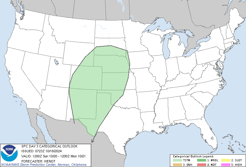
...THERE IS A MARGINAL RISK OF SEVERE THUNDERSTORMS SATURDAY INTO
SATURDAY NIGHT ACROSS EASTERN NEW MEXICO AND ADJACENT PORTIONS OF
THE OKLAHOMA PANHANDLE AND WESTERN TEXAS...
...SUMMARY...
Strong thunderstorms are possible across eastern New Mexico and
perhaps portions of adjacent western Texas Saturday into Saturday
night, accompanied by at least some risk for severe weather.
...Synopsis...
Inland of the North American Pacific coast, strong zonal flow will
prevail across much of Canada through this period. More amplified,
but generally much weaker, flow will prevail across the southern
mid- to subtropical latitudes. The latter regime is likely to
include a notable lingering mid-level low near the Four Corners.
Only a very slow eastward/northeast movement of this low is forecast
Saturday through Saturday night, mostly in response to perturbations
pivoting around its periphery.
Downstream of the low, models indicate that ridging will build
across the southeastern Great Plains and lower through middle
Mississippi Valley. In lower levels, cool surface ridging is
forecast to remain prominent from the lower Great Lakes/upper Ohio
Valley vicinity into the northern Gulf of Mexico and northwestern
Gulf Coast.
Although surface troughing to the lee of the southern Rockies is
likely to continue to weaken, south/southeasterly low-level flow
will persist across the high plains into the higher terrain and
contribute to further moistening of Gulf origins, beneath broadly
cyclonic and diffluent mid/upper flow.
...Eastern New Mexico and adjacent western Texas...
With the mid-level cold core remaining generally confined to the
Colorado Plateau, lapse rates across and east of the Sangre de
Cristo and Sacramento Mountains, through much of eastern New Mexico,
may remain relatively weak on Saturday. This, coupled with further
weakening of the lee surface troughing, does not appear particularly
conducive to severe storm development. However, with some
additional boundary-layer moistening beneath at least modestly cool
mid-levels, CAPE may exceed 500 J/kg (and perhaps approach 1000
J/kg) by late Saturday afternoon, in the presence of continuing
favorable shear profiles for supercells. One short wave
perturbation pivoting around the southeastern periphery of the
mid-level low may enhance convective development near or shortly
after peak destabilization. However, there remains sizable spread
within the model output concerning this feature.
..Kerr.. 10/17/2024
NOTE: THE NEXT DAY 3 OUTLOOK IS SCHEDULED BY 1930Z